

The Abridged version:
- Triple-digit temperatures are expected to hit the Sacramento area Tuesday and last through Wednesday, reaching 105 degrees in parts of the Sacramento Valley.
- Local meteorologist Mark Finan warned of wildfire risk as some areas along the crest and the eastern portion of the Sierra Nevada could see afternoon rain showers and possibly thunderstorms and lightning.
- The record high for July 14 is 114 degrees and the average high for this time of year is 93 degrees.
Triple-digit temperatures are expected in the Sacramento area after what’s been a relatively cool start to the summer, and with them, the risk of wildfires.
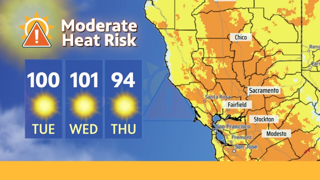
Sacramento is slated to endure temperatures of 100 degrees Tuesday and 101 degrees Wednesday, following several days of balmy temperatures left behind from a monsoon that shifted winds. The National Weather Service office in Sacramento warned of moderate heat for Tuesday and Wednesday, advising people to remain in a cool environment during the warmer portion of the day.
The heat this week could affect people who are sensitive to warm temperatures, including those who can’t adequately cool off or hydrate, according to the weather service.
Local meteorologist Mark Finan, who’s been forecasting weather in Sacramento since 1991, said temperatures are warm but haven’t reached extreme levels.
“If you’re working outside in the bright sun at 4 in the afternoon, you feel it,” he said.
“But that’s just part of living in this area during the summertime.”
How hot will it get in the Sacramento Valley?
Finan said while the triple-digit temperatures forecast for Sacramento this week could be some of the hottest weather the area has seen this year, it’s not extreme for this season.
Areas north of Chico could see temperatures above 100 degrees, with temperatures reaching 104 and 105 degrees in parts of the Sacramento Valley. Temperatures in Redding, he said, surpassed 100 degrees four times this month and similar weather is expected this week.
“We are looking at temperatures that are hot, but not excessive for this time of year … but certainly noteworthy,” Finan said.
The record high for July 14 is 114 degrees and the average high for this time of year is 93 degrees, he said.
What about rain?
Finan said wet conditions are possible Tuesday morning in the Sacramento Valley before clearing to make way for sunny, clear skies. He warned of wildfire risk as some areas along the crest and the eastern portion of the Sierra Nevada could see afternoon rain showers and possibly thunderstorms and lightning.
By Wednesday, he said, both the Sierra Nevada and the Sacramento Valley are forecast to be dry and hot.
Looking ahead to the weekend
The rest of the week is expected to remain hot and sunny, with temperatures gradually dropping to the low 90s ahead of the weekend.
Finan uploads daily regional weather updates to YouTube to his nearly 23,000 subscribers. In a video Monday titled “Valley Heat And Sierra Storms,” he said a trough — an area of low pressure that helps to steer winds — will slightly cool the triple-digit heat Wednesday night, making way for daytime temperatures that range from the high 80s to low 90s starting Thursday.
Nothing more than partly cloudy skies are expected throughout the weekend, according to the weather service.
On Friday, temperatures are forecast to reach a high of 89 degrees and a low of around 58 degrees before slightly creeping up to the low 90s on Sunday.
Hotter weather, Finan said, could make a reappearance next week.
Brianna Taylor is an audience engagement reporter for Abridged by PBS KVIE.